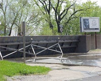
 Mad Creek, Muscatine, Iowa
Flood Risk Management (Section 205)
Flood Risk Management (Section 205)
The Mad Creek watershed drains approximately 17.3 square miles in the eastern portion of the City of Muscatine and areas to the north in Muscatine County. Due to the nature of the watershed and intensive development in the downtown area, Mad Creek is prone to flash flooding, experiencing flooding events in 1991, 1993, and 1998. Alternative plans were developed and evaluated based on appropriate engineering, economic, environmental, cultural, and social factors.
Major components of the selected plan include:
- Raising the height of approximately 2,300 linear feet of existing levees, 1,700 linear feet of existing floodwalls by 2 feet;
- 230 linear feet of new floodwall;
- New bulkhead closure gate at Mississippi Drive;
- New overhead closure gate at 2nd Street;
- New swing gate just upstream on 2nd Street;
- Installation of a new closure structure across the railroad south of Washington Street.
The selected plan also includes improving a section of the Mad Creek channel upstream of 2nd Street to reduce flood stages and installing an enhanced flood warning system. The project cost estimate is $3.45 million and the estimated benefit-cost ratio is 3.4 to 1.
Waterloo, Iowa
Planning Assistance to States
In the 1920's, the Corps built a floodwall to protect the City of Waterloo. Since then, a local flood protection project was constructed behind the 1920's floodwall, where the actual levee and flood wall system were completed in the early 1980's and were designed for a 100-year level of flood protection. However, the same floodwall that protects the City from the ravages of floods also creates a barrier to the water during times of normal flow. While the City is delighted with the protection the floodwall has provided, it would like the community to have better access to the riverfront. The City also wants to examine how, during times of low flow, it could maintain a steadier pool through the Cedar River Corridor to allow community access. Additionally, the City wants to examine the structural integrity of two dams, noting the lower dam is key to maintaining such a pool in the corridor.
Finally, the City would like to determine how the Rath Neighborhood Area could be incorporated in the Riverwalk area.
The Rath Neighborhood Area is a designated Environmental Protection Agency (EPA) Brownfields Demonstration Pilot.
A Brownfields, as defined by the EPA, is a site, or portion thereof, that has actual or perceived contamination and an active potential for redevelopment or reuse. The City requested the Corps' assistance in identifying potential land uses once it has completed site assessment and remediation.
The Corps developed the following analyses for the City and incorporated them into one report:
Hydraulic/Hydrologic Analysis
The Corps conducted a hydraulic and hydrologic analysis to determine the effects of modifying the area between the 1920's floodwall and the recently built floodwall to accommodate a proposed "Riverwalk" and greenspace. This analysis included considerations for potential pool regulation to promote recreational use of the river, effects of a regulated pool on sedimentation, storm sewer system, floodplain, and dam requirements. A summary of the analysis will be included in the Land Use Plan report.
Structural Analysis
The Corps inspected the existing dam structure to determine its level of structural integrity. A structural stability analysis was done to determine the stability of the structure as it is currently used and with modification to accommodate rise of the pool.
North Fabius River Scotland County, Missouri
14 Emergency Streambank and Shoreline Protection (Section 14)
In the 1950's, the North Fabius River channel was straightened north of State Route A so that flows could be directed through the State Route A Bridge at this location (also called Rainbow Bridge). Since that time, meandering processes have reestablished and migration is occurring down valley. In addition, when the North Fabius River meets or exceeds its channel capacity, the river continues to remove the earth embank-ments upstream of State Route A Highway and Rainbow Bridge. This has caused the loss of approximately 2,340 linear feet of bankline, vegetation, and trees. The channel cross section is changing, thus shifting concentrated flows to the right side of the bridge abutments, threatening the integrity of the bridge structure and roadway embankments. Erosion is caused from high water periods, bank sloughing, over-bank flooding, and runoff. Since the upstream channel was straightened, a comparison of aerial photographs shows a significant difference in conditions upstream of the bridge over time.
The outer bank has eroded to the point that concentrated near-bank currents are misaligned with the opening of the bridge.
There is also a large point bar on the right descending bank beginning approximately 10 feet upstream of the bridge. These problems have threatened the viability of the Rainbow Bridge structure and State Route A roadway embankments. The Missouri Department of Transportation reports that State Route A at the Rainbow Bridge has an average daily traffic count of 320 vehicles. Loss of this road and bridge would be a hardship for area residents and would require a 38-mile detour route.
Four alternatives were reviewed, and the following was selected:
Provide streambank protection in two areas upstream of the bridge:
- In Area 1, excavate approximately 11,000 cubic yards of sand fill from the point bar (shoal); fill and shape existing bankline with riprap on the same reach; and
- Place longitudinal stone fill toe and riprap protection in Area 2 with tiebacks for a distance of approximately 1,000 feet.
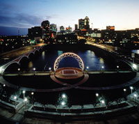 Des Moines and Raccoon River • Des Moines, Iowa
Flood Damage Reduction (Specifically Authorized)
The study area is the City of Des Moines in Polk County, Iowa. Des Moines is located in central Iowa at the confluence of the Des Moines and Raccoon Rivers. In addition to the Des Moines and Raccoon Rivers, portions of several smaller tributaries, including Walnut Creek, Fourmile Creek, and 7th Ward Ditch, are contained within the City.
The Des Moines River above the confluence with the Raccoon River has a drainage area of 6,245 square miles, draining areas north of Des Moines in north-central Iowa and southwest Minnesota. The Raccoon River enters the Des Moines River from the west near the Des Moines central business district and has a drainage area of 3,629 square miles. Although Saylorville Dam and Reservoir largely regulate the Des Moines River, significant storm events such as in July 1993 and June of 2008 caused flooding in areas throughout Des Moines. The Raccoon River has no major flood control reservoirs and exhibits significant fluctuations in its flows.
The Red Rock Dam and Lake Red Rock project is located on the Des Moines River just downstream from the City of Des Moines.
The principal focus of a study completed in 2005 was to identify alternatives for flood risk management within the City of Des Moines. The study recommends:
- Reconstructing the Birdland Park Levee
- Improving the recreational trail at Birdland Park
- Improving the levee to protect the Central Place Business District
- Reconstructing 19 levee closures in downtown Des Moines
- Creating 16 acres of wetlands and upland forest habitat at the Chichaqua mitigation site
Construction was authorized in the Water Resources Development Act of 2007 and in the 2010 Energy and Water Development Appropriations Act.
Construction on the Birdland Park and Central Place Levee System projects began in 2010 and is anticipated to be completed in 2011.
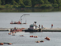
Aquatic Ecosystem Restoration (Section 206)
Ventura Marsh is a large wetland complex located within an approximately 800-acre Iowa Department of Natural Resources wildlife area. It flows into Clear Lake, which is the third largest natural lake in Iowa, covering 3,600 acres.
Ventura Marsh is an aging wetland system. In the 1940s, a water control (stoplog) structure was constructed at the marsh outlet to impound water higher in the marsh. The stable high water level has caused portions of it to accelerate to an open marsh stage. Rough fish foraging and spawning activities in Ventura Marsh stir up the highly organic bottom sediments, thereby decreasing the marsh water quality and reducing the vegetation coverage. These factors limit usage of the marsh by aquatic birds and furbearers. Consequently, the marsh's habitat potential for these species is not being reached.
Systemically, the marsh is also limiting the habitat value of Clear Lake because it does not act as a natural filtering system for the water entering the lake and because it is used by rough fish, specifically carp, for recruitment. As a result, the water quality of Clear Lake and the quality of the Clear Lake fishery are decreased. The success of the Clear Lake restoration efforts that are being undertaken by the state depends on solving these problems in the marsh.
This project presents the opportunity to improve site specific and systemic habitat benefits through improved marsh structure and function. The site specific goal is to improve Ventura Marsh aquatic habitat quality and diversity and maintain it as a high quality hemi-marsh (50:50 ratio open water and emergent vegetation). The systemic goal is to provide habitat-related water quality and fishery benefits to the Clear Lake Ecosystem by improving the Ventura Marsh's ability to process and store nutrients. Objectives for meeting these goals are as follows:
- Increase Rooted Emergent and Submergent Vegetation Coverage and Diversity in Ventura Marsh
- Increase Sediment Compaction in Ventura Marsh
- Decrease the Amount of Nutrients and Sediment in the Ventura Marsh Discharge
- Decrease Rough Fish Population in Ventura Marsh
- Increase the Suitability of Aquatic Bird Breeding Habitat
- Increase Suitability of Furbearer Habitat
In order to achieve the goals and objectives of this project, a number of management measures were considered in the categories of water control, improved marsh function, and rough fish control. These were compared based on habitat benefits and cost to determine the best overall project alternative. The Recommended Plan consists of the following activities:
- demolishing the existing stoplog structure and grate;
- constructing a new controlled spillway;
- constructing a marsh pump station and outlet to Clear Lake;
- dredging a water flow channel from the deepest section of the marsh to the pump station;
- dredging forebay immediately adjacent to the pump station;
- constructing two grade control structures;
- excavating one sediment detention basin;
- constructing approximately 10,000 lineal feet of vegetation cutting in the upper marsh; and
- installing rough fish control features at the pump station and the new controlled spillway.
 Illinois River Ecosystem Restoration
General Investigation
The study area encompasses the entire Illinois River Watershed. The study will identify the Federal and State interest in addressing problems related to the loss of backwaters and side channels due to sedimentation, destabilized tributary streams, changed hydrologic regimes and water fluctuations, and other impacts on the system caused by human activity.
For simplicity, the tasks are best viewed in major groupings. There are generally two types of efforts: (1) system evaluations focused on assessing the overall watershed needs and general locations for restoration, and (2) site-specific evaluations focused on developing detailed restoration options for possible implementation at specific sites. A final grouping of tasks relates to report preparation and processing.
The system and site-specific evaluations will investigate restoration opportunities falling into four focus areas:
- Watershed Stabilization - Address tributary alterations and land uses, conservation easements, wetlands, water retention, riparian filter strips, and stream restoration.
- Side Channel and Backwater Modification - Consider opportunities to restore habits in these areas, including off-channel deep water habitat, backwater lakes, side channels, constructing islands, etc. acquisition or conservation easements of some floodplain lands.
- Water Level Management - Evaluate options to reduce rapid fluctuations and naturalize flows.
- Floodplain Restoration and Protection - Evaluate floodplain use, potential restoration of floodplain function, and value/potential for use of Conservation Reserve Enhancement Program (CREP).
The system evaluations of these four areas will begin shortly after the study is initiated. Then, as the system needs and the most promising project locations are identified, efforts will begin on the site-specific evaluations. Due to cost and time limitations, only two to three specific sites will be developed in detail during the study. If greater system needs were identified, then a larger list of potential improvements would be prepared and recommended for authorization based on a lesser level of detail.